![](/images/other/stat-length.png)
![Randonnée A pied La Val - Wengen - La Valle - IT-15B - Photo](https://media.geolcdn.com/t/1900/400/ext.pjpeg?maxdim=2&url=https%3A%2F%2Fstatic1.geolcdn.com%2Fsiteimages%2Fupload%2Ffiles%2F1545311037marcheuse_200dpi.jpg)
IT-15B
SityTrail - itinéraires balisés pédestres
Tous les sentiers balisés d’Europe GUIDE+
![Longueur](/images/other/stat-length.png)
Longueur
4 km
![Altitude max](https://static1.geolcdn.com/siteimages/upload/files/1508320355ic_sort_altitude_max_24dp.png)
Altitude max
2129 m
![Dénivelé positif](https://static1.geolcdn.com/siteimages/upload/files/1508320355ic_sort_den_pos_24dp.png)
Dénivelé positif
427 m
![Km-Effort](/images/other/stat-length.png)
Km-Effort
8,5 km
![Altitude min](https://static1.geolcdn.com/siteimages/upload/files/1508320355ic_sort_altitude_min_24dp.png)
Altitude min
1702 m
![Dénivelé négatif](https://static1.geolcdn.com/siteimages/upload/files/1508320355ic_sort_den_neg_24dp.png)
Dénivelé négatif
79 m
![Boucle](https://static1.geolcdn.com/siteimages/upload/files/16400158638029165_repeat_loop_refresh_sync_direction_icon.png)
Boucle
Non
Balise
Date de création :
2022-02-14 23:02:51.433
Dernière modification :
2022-02-28 17:02:46.824
![A pied](https://static1.geolcdn.com/sitytour/trail-icons/100.png)
1h56
Difficulté : Facile
![Scannez ce code QR pour ouvrir la randonnée dans l'application SityTrail](https://capi.geolives.com/qq0zvz2zws4bq2lad0pu/sitytour/trails/3112317/qr.png?size=200)
Application GPS de randonnée GRATUITE
À propos
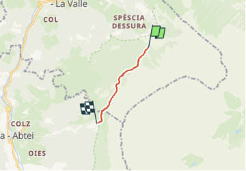
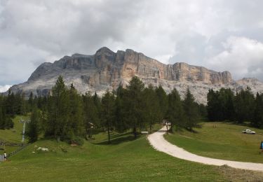
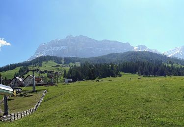
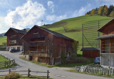
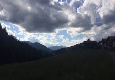
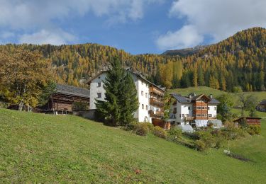
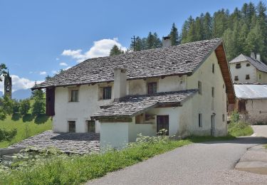
Randonnée A pied de 4 km à découvrir à Trentin-Haut-Adige, Haut-Adige, La Val - Wengen - La Valle. Cette randonnée est proposée par SityTrail - itinéraires balisés pédestres.
Description
Randonnée créée par Alpenverein Südtirol (AVS).
Localisation
Pays :
Italie
Région :
Trentin-Haut-Adige
Département/Province :
Haut-Adige
Commune :
La Val - Wengen - La Valle
Localité :
Unknown
Départ:(Dec)
Départ:(UTM)
726884 ; 5169493 (32T) N.
Commentaires
Randonnées à proximité
![Randonnée Marche Marèo - Enneberg - Marebbe - J6 La villa refuge Gardenacia - Photo](https://media.geolcdn.com/t/375/260/fd4b5dad-1ed4-451b-9973-068f6800e1dd.jpg&format=jpg&maxdim=2)
![Marche Marche](https://static1.geolcdn.com/sitytour/trail-icons/101.png)
J6 La villa refuge Gardenacia
Marche
Très difficile
Marèo - Enneberg - Marebbe,
Trentin-Haut-Adige,
Haut-Adige,
Italie
![](/images/other/stat-length.png)
15,3 km | 31 km-effort
7h 6min
![](https://static1.geolcdn.com/siteimages/upload/files/16400158638029165_repeat_loop_refresh_sync_direction_icon.png)
Non
![Randonnée A pied Marèo - Enneberg - Marebbe - IT-10 - Photo](https://media.geolcdn.com/t/375/260/22c867db-e156-42eb-a9c0-042d0fd3e5fb.jpeg&format=jpg&maxdim=2)
![A pied A pied](https://static1.geolcdn.com/sitytour/trail-icons/100.png)
IT-10
A pied
Facile
Marèo - Enneberg - Marebbe,
Trentin-Haut-Adige,
Haut-Adige,
Italie
![](/images/other/stat-length.png)
8,9 km | 11,6 km-effort
2h 38min
![](https://static1.geolcdn.com/siteimages/upload/files/16400158638029165_repeat_loop_refresh_sync_direction_icon.png)
Non
![Randonnée A pied Marèo - Enneberg - Marebbe - IT-17 - Photo](https://media.geolcdn.com/t/375/260/eba22839-315b-4c62-8c60-f4184488c9fc.jpeg&format=jpg&maxdim=2)
![A pied A pied](https://static1.geolcdn.com/sitytour/trail-icons/100.png)
IT-17
A pied
Facile
Marèo - Enneberg - Marebbe,
Trentin-Haut-Adige,
Haut-Adige,
Italie
![](/images/other/stat-length.png)
8,4 km | 18,8 km-effort
4h 16min
![](https://static1.geolcdn.com/siteimages/upload/files/16400158638029165_repeat_loop_refresh_sync_direction_icon.png)
Non
![Randonnée A pied Badia - Abtei - IT-7A - Photo](https://media.geolcdn.com/t/375/260/7513433d-8258-4640-8bb1-d076e865b7b9.jpeg&format=jpg&maxdim=2)
![A pied A pied](https://static1.geolcdn.com/sitytour/trail-icons/100.png)
IT-7A
A pied
Facile
Badia - Abtei,
Trentin-Haut-Adige,
Haut-Adige,
Italie
![](/images/other/stat-length.png)
4,1 km | 9,2 km-effort
2h 5min
![](https://static1.geolcdn.com/siteimages/upload/files/16400158638029165_repeat_loop_refresh_sync_direction_icon.png)
Non
![Randonnée A pied La Val - Wengen - La Valle - IT-8 - Photo](https://media.geolcdn.com/t/375/260/fc3a34f7-64ea-405d-be84-99a603060853.jpeg&format=jpg&maxdim=2)
![A pied A pied](https://static1.geolcdn.com/sitytour/trail-icons/100.png)
IT-8
A pied
Facile
La Val - Wengen - La Valle,
Trentin-Haut-Adige,
Haut-Adige,
Italie
![](/images/other/stat-length.png)
6,6 km | 9 km-effort
2h 3min
![](https://static1.geolcdn.com/siteimages/upload/files/16400158638029165_repeat_loop_refresh_sync_direction_icon.png)
Non
![Randonnée A pied La Val - Wengen - La Valle - IT-17 - Photo](https://media.geolcdn.com/t/375/260/07746ad5-29ba-421f-8875-1f63c7b3c161.jpeg&format=jpg&maxdim=2)
![A pied A pied](https://static1.geolcdn.com/sitytour/trail-icons/100.png)
IT-17
A pied
Facile
La Val - Wengen - La Valle,
Trentin-Haut-Adige,
Haut-Adige,
Italie
![](/images/other/stat-length.png)
6 km | 12 km-effort
2h 43min
![](https://static1.geolcdn.com/siteimages/upload/files/16400158638029165_repeat_loop_refresh_sync_direction_icon.png)
Non
![Randonnée A pied La Val - Wengen - La Valle - IT-2 - Photo](https://media.geolcdn.com/t/375/260/b427b6fe-2165-4349-96ff-0fb52ec29347.jpeg&format=jpg&maxdim=2)
![A pied A pied](https://static1.geolcdn.com/sitytour/trail-icons/100.png)
IT-2
A pied
Facile
La Val - Wengen - La Valle,
Trentin-Haut-Adige,
Haut-Adige,
Italie
![](/images/other/stat-length.png)
3,2 km | 4,6 km-effort
1h 2min
![](https://static1.geolcdn.com/siteimages/upload/files/16400158638029165_repeat_loop_refresh_sync_direction_icon.png)
Non
![Randonnée A pied La Val - Wengen - La Valle - IT-16 - Photo](https://media.geolcdn.com/t/375/260/bf9483bd-3e2d-4b0a-8c7a-498578422738.jpeg&format=jpg&maxdim=2)
![A pied A pied](https://static1.geolcdn.com/sitytour/trail-icons/100.png)
IT-16
A pied
Facile
La Val - Wengen - La Valle,
Trentin-Haut-Adige,
Haut-Adige,
Italie
![](/images/other/stat-length.png)
5,1 km | 7,9 km-effort
1h 47min
![](https://static1.geolcdn.com/siteimages/upload/files/16400158638029165_repeat_loop_refresh_sync_direction_icon.png)
Non
![Randonnée A pied La Val - Wengen - La Valle - IT-6 - Photo](https://media.geolcdn.com/t/375/260/8f4905da-94aa-4ec4-8ce4-df8bb00eff25.jpeg&format=jpg&maxdim=2)
![A pied A pied](https://static1.geolcdn.com/sitytour/trail-icons/100.png)
IT-6
A pied
Facile
La Val - Wengen - La Valle,
Trentin-Haut-Adige,
Haut-Adige,
Italie
![](/images/other/stat-length.png)
5,9 km | 8,5 km-effort
1h 55min
![](https://static1.geolcdn.com/siteimages/upload/files/16400158638029165_repeat_loop_refresh_sync_direction_icon.png)
Non